Bird's Eye View
Jan. 25, 2016
Advances in environmental performance improvement.
As Shell continues operations in the oil sands of Alberta, it is also working on new technologies that help in returning the land back to a natural state. A pilot project using unmanned aerial vehicles (UAV) is providing data needed to accurately monitor and measure the success of these reclamation efforts across large areas of land.
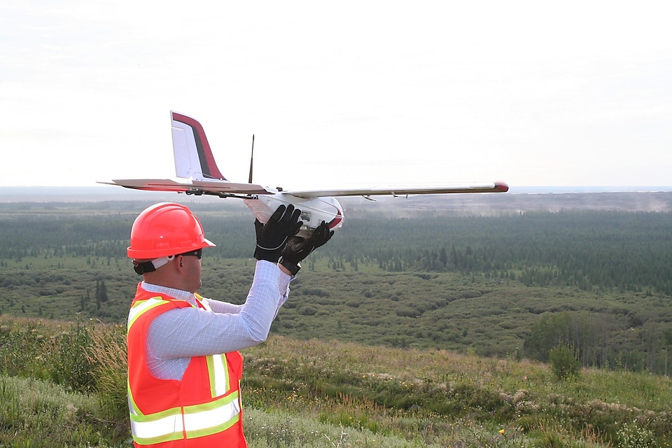
A member of the UAV team prepares to use the new UAV aircraft technology.
UAVs collect high-resolution data with cameras and sensors. Data can then be geospatially analyzed to measure vegetation success in natural and reclamation areas. The project is a collaboration with Canada’s Oil Sands Innovation Alliance (COSIA), an alliance of oil sands producers focused on accelerating the pace of improvement in environmental performance in Canada’s oil sands through collaborative action and innovation.
“Once Shell determines that this technology is robust and reliable, we can share it with our industry peers in COSIA,” says Clayton Dubyk, senior advisor, Environment. “In some cases Shell is a recipient of technologies from others, but in this case, we are contributing our learnings to 13 other companies. That’s the value of COSIA.”
Creating a robust dataset that will support reclamation certification by regulators is a constant challenge for oil sands companies. Defining reclamation success traditionally depends on physically measuring metrics such as tree height, vegetation composition and soil moisture that are repeatedly monitored over the course of decades.
The Shell Geomatics group recently completed a pilot project that used a UAV to capture high-resolution digital images and digital elevation data to determine soil stockpile volumes. Preliminary findings indicate that UAV results were within 5% of the ground survey and have shown a significant reduction in HSE exposure, especially to people. The intent is that this technique can be altered to measure reclamation success.
The need for smaller, more cost-effective units has become even more apparent in the current economic climate. Employing a full-size aircraft can be costly, especially for relatively small areas. This is where the use of an unmanned aircraft can play a crucial role. They are easily deployed, low cost, accurate and easy to use once employees receive appropriate training.
In some situations, in fact, a UAV is likely the only alternative for collecting data from an inaccessible or hazardous environment. The scale of reclamation monitoring in the oil sands makes the use of UAVs ideal since landforms such as tailings ponds and soil stockpiles easily allow for maintaining line-of-site with the UAV, a current Transport Canada requirement. With the use of UAV technology, Shell hopes to reduce risk and costs and increase the efficiency of reclamation monitoring.
“For Shell, a technology company that cares for its people and the environment, unmanned aerial systems technology gives us tangible business value and reduces HSSE exposure,” says Ayo Adediran, geo-information consultant, Upstream Americas Geomatics.
More in Media

News and Media Releases
News and Media Releases - All media releases published by Royal Dutch Shell plc this year, and archived releases from the past six years.
Media Inquiries
If you are a member of the media, we welcome inquiries related to Shell Canada’s corporate activities. Click to access the submission form.